Bodmin Moor
Goon Brenn
Cornwall's Ancient Moor
Web: www.bodminmoor.co.uk
Web: www.visitcornwall.com/regions/bodmin-moor
Map
A large tract of beautiful, windswept countryside, rich in history and legend, lying empty and almost unknown in the middle of England's most popular holiday county. It is 80 square miles in size, and dates from the Carboniferous period of geological history.
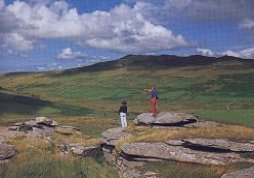
Bodmin Moor (originally known as Fowey Moor) with its rolling landscapes with dramatic granite outcrops have led to it being designated an Area of Outstanding Natural Beauty, about 100 square miles in area. Particularly well known to visitors to Cornwall today, because the A30 which cuts right across the moor from north-east to south-west, was originally built as a toll road in the 1770's is the main road in to Cornwall.
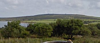
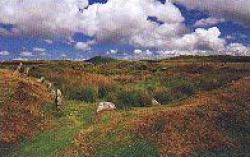
Most of the moor lies above 800 feet, and the highest point, also the highest point in Cornwall, is Brown Willy at 1377 feet, with Roughtor at 1311 feet. Both can be reached after a brisk walk from the nearest car park at the end of the road from Camelford. Cornwall's two most important rivers, the Camel and the Fowey, both rise on the Moor. And there are three reservoirs, Colliford, Crowdy and Siblyback which supply water for a large part of the county's population. The legendary Dozmary Pool is just south of Bolventor. Considerable areas of the moor are poorly drained and form marshes. The rest of the moor is mostly rough pasture or overgrown with heather and other low vegetation.
There are several small villages on or around the moor, some are ancient hamlets, and others which appeared during the mining boom. In the north there is the pretty village of Altarnun and its close neighbours Five Lanes and Trewint. Further south is North Hill, Henwood, Minions, Upton Cross, Pensilva, Crows Nest, Darite, Tremar, Common Moor and St. Cleer, all on the eastern side of the moor. Then in a clockwise direction there is St. Neot, Warleggan, Cardinham, Blisland and St. Breward. In the centre of the moor is the village of Bolventor, once on the A30 but now bypassed, the famous Jamaica Inn, and Temple with its tiny church. Surrounding the moor are the larger towns of Camelford, Launceston, Callington, Liskeard and Bodmin.
Bodmin Moor has been at the heart of all that is Cornwall since man made his first primitive home here almost 7,000 years ago. For the visitor with sufficient time, and the interest to seek it out, history lies on every rocky tor, and lurks in each lonely valley, side-by-side with romance and legend. There can be few visitors to Cornwall who have not seen this expanse of granite upland. Approached from the east, its dark heights dominate the horizon. The rugged, boulder-strewn tors have changed little over the centuries. Stone Age man; Roman trader; Dark Age Saint; Saxon Chieftain; Norman Earl; Medieval farmer - even King Arthur himself - would feel at home were they to return to the heart of the moor today. This sense of timelessness is felt by all who come to know and love Bodmin Moor. To strike out across the coarse grass, leaving behind the grey stone moor-side hamlets, is to stride back into Cornwall's History. Almost every age of man has left its brief mark here and the moor is littered with ancient sites. There are old tin streaming works, granite quarries which have supplied major constructions all over the country, and the remains of tin and copper mines which have earned fortunes for the miners.
A phantom wild cat purported to live on Bodmin Moor became a centre of many sightings with occasional reports of mutilated slain livestock: the alleged panther-like cats of the region came to be popularly known as the Beast of Bodmin Moor.
Places of Interest
Brown Gelly Brown Willy Caradon Hill The Cheesewring Colliford Lake Crowdy Reservoir
Dozmary Pool Daniel Gumb's Cave Fox Tor Garrow Tor Golitha Falls The Hurlers Jubilee Rock
Kilmar Tor King Arthur's Bed King Arthurs's Hall King Doniert's Stone The Longstone Rillaton Barrow Rough Tor
Sharp Tor Siblyback Reservoir Stowe's Pound Temple Church Tregarrick Tor Trethevy Quiot Trewortha Bronze Age Farm
Brown Gelly
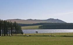
 Brown Gelly is one of those hills you can see from miles around. Five cairns are located along the ridge of Brown Gelly which runs roughly north south and rises to 1122 feet. There are views over Dozmary Pool, Colliford Lake, Siblyback Lake and the Fowey River.
Brown Willy
 The highest hill in Cornwall is 1377 feet. Situated in the centre of the moor to the north of the A30 road, about 2.5 miles north-west of Bolventor, it dominates the moorland scene. The source of the River Fowey is nearby and its height causes a rain shadow downwind. There are hut circles and tumuli on the slopes about its long-ridged peak. It has a wonderfully remote atmosphere and on a very clear day you can see as far as Lundy Island and Exmoor to the north, Trevose Head to the west and St. Austell to the south.
Caradon Hill
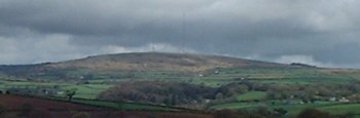 The 800 foot television mast erected in 1961 which rises above the tumuli and roofless mine buildings of this ancient hill, can be seen for many miles around, and is about four miles north of Liskeard. Reaching 1213 feet, the hill provides a useful landmark for those moorland walkers who are not expert map-readers. During the Civil War King Charles I, accompanied by Prince Maurice, mustered his troops here on the 2nd August 1644 before they went on to a notable victory at Castle Dore. Copper was discovered here in 1837, and signalled the beginning of the boom which changed the character of the eastern moor. There are the remains of mines and mining everywhere. Thousands of people once worked the mines here. The track of the old mineral railway line can still be traced contouring around the hill. On the south-eastern slope of the hill is Tokenbury Corner, a large piece of open common land with amazing views across all of south east cornwall. The mining villages of Pensilva, Crows Nest, Darite, Minions and Upton Cross are all situated around the base of the hill.
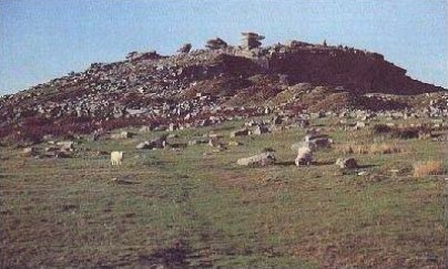
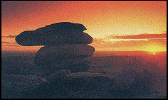
The Cheesewring
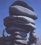 A natural formation of much-photographed balancing rocks on Stowe's Hill standing 32 feet high, 1210 feet above sea level, and located close to Minions village. From this spot there is a magnificent view over the Tamar Valley to the east and open moorland to the west. Close at hand is the long-neglected Cheesewring quarry, Daniel Gumb's 'house', and the Iron Age fort known as Stowe's Pound. A short distance across the moor to the west is 'the gold diggings'. Gold was found in the mines and rivers on the moor, but in no great quantities. This was a favourite outing for Sunday schools in the 19th century, when the children would travel here on the old mineral railway, to the quarry which was started in 1839. Today the quarries which once sent tons of granite down the railway to Liskeard and Looe, are only used by climbers.
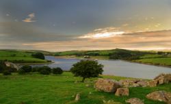
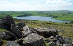
Colliford Lake
 Not far west of Siblyback and overlooked by Brown Gelly is the 900 acre Colliford Reservoir situated just south of Jamaica Inn, the famous smugglers' haunt immortalised by Daphne Du Maurier. Colliford is a tranquil place with ample car parking and plenty of space for picnics and lakeside walks. There are three way-marked walks starting from the main car park which include the neighbouring moorland. The large Nature Reserve has become an important site for over-wintering wildfowl. The lake offers traditional fly fishing for natural brown trout and is regarded as Cornwall's premier brown trout fishery. The reservoir was constructed in 1982 and flooded in 1984. The water drops off the moor as the St. Neot River, flowing down through the village of St. Neot before joining the River Fowey. Now managed by the South West Lakes Trust as Colliford Lake.
Crowdy Reservoir
 Crowdy Reservoir constructed in 1973 and some 115 acres in size is located on the west side of the moor, two miles east of Camelford, and has fishing and leisure/sport activities managed by the South West Lakes Trust. The area around Crowdy Reservoir and Davidstow woods are designated a 'Site of Special Scientific Interest', particularly noted for the very wide species of birds that are to be seen here. The old war time airfield of Davidstow and its museum is nearby.
Daniel Gumb's Cave
 Located close to Cheesewring Quarry, near Minions, Daniel Gumb was born in 1703, when he grew up and worked at the quarry, he built himself a stone 'cave' near the bottom of the quarry. You can still see the place though much reduced from the original three room thirty foot long 'house'. In this house he and his wife raised nine children, he carved his name and date 1735 into a stone, and because he was interested in astronomy also carved out mathematical signs into the long stone that served as a roof. When the Cheesewring quarry was started in the mid 1800's the home was broken up, Daniel Gumb had died in 1776 and many of his offspring have emigrated to the Americas. What remains now is only a small part of the original. Some of his work as a stone mason can be found on tombstones in several local graveyards including that at Linkinhorne.
Dozmary Pool
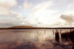 About thirty acres in extent and 885 feet above sea level, this dark and lonely place has always fascinated local inhabitants and visitors alike. Its shores were probably inhabited before any other inland area of Cornwall. Associated with the legend of King Arthur and with Excalibur, King Arthur's sword given to him by the Lady of the Lake. It is said that after Arthur was mortally wounded he ordered that Excalibur be thrown into the lake. This was done and after the sword was cast into the lake a woman's hand caught it and held it aloft before taking it under the surface. And the ghost of Jan Tregeagle, who to keep his soul from the Devil was set a series of impossible tasks. The first was to empty Dozmary Pool with a holed limpet shell. It has since been proved that the lake does have a bottom as it dried out during the last century! - Dozmary lies just south of Bolventor and the famous Jamaica Inn. An ice making industry was once carried out here, the remnants of the old landing stages are still visible. The pool outfalls into Colliford Lake.
Fox Tor
 Easily accessible from the road above Altarnun, this tor rising to 1129 feet on the northern edge of East Moor gives excellent views in most directions. The small stone circle of Nine Stones is nearby.
Garrow Tor
 At the summit of Garrow Tor which reaches 1080 feet and is about two miles north-west of Bolventor, are granite rock outcrops and panoramic views, including Caradon Hill to the south, Rough Tor and Brown Willy to the north, Butter's Tor to the east, clay country to the west and the Atlantic Ocean to the north-west. The hill also bears extensive evidence of early settlement, including a massive stone hedge, Bronze Age settlements and hut circles and Medieval settlements. The De Lank River runs past the eastern flank of the tor from north to south, before swinging south-west around the southern foot of the hill. King Arthur's Hall lies half a mile to the south-west. The remains of Garrow farm are still standing on the east side of the hill.
Golitha Falls
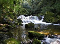 Situated close to Redgate, just off the St. Neot road, Golitha Falls is a well known local beauty spot, where the River Fowey drops through an attractive wooded valley in a series of falls as though anxious to leave the moor behind. It is carpeted with bluebells in the spring and with mushrooms in the autumn. There is a car park and toilets by the road leading to a level riverside walk. The bridge was built in 1876 to replace an earlier ford. Beside the path in the woods can be seen the massive walls built in the 1850's to take the water wheel used in the Wheal Victoria Mine. Now a National Nature Reserve. The reserve is home to dormice which reside in the ancient hazel coppice. Noctule, brown long-eared and lesser horseshoe bats have been recorded. Dippers can be seen bobbing in the river, with nuthatch, tree-creeper and pied flycatcher joining more common birds in the dawn chorus. The river also supports healthy populations of both salmon and sea trout which in turn provides opportunities for fly fishing. Otters are often seen exploring the falls. Inkie's Smokehouse BBQ, which is based next to the beautiful Golitha Falls nature reserve has a growing reputation for its smoked meats, burgers and wraps.
The Hurlers
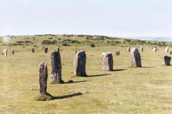 On the edge of the village of Minions. Originally the stones here formed part of three circles, erected about 1500 BC. They are probably the best known stone circles on the moor because they are so readily accessible. Built within a relatively short time of Stonehenge, many theories have been put forward about the uses to which they were put. They have been variously described as places of human sacrifice, and a meeting place for moorland chiefs. Legend has it that the stones were once men and women, turned to stone for playing the ancient game of hurling on a Sunday - hence the name. Two other monoliths, the Pipers, are 330 feet south-west of the middle circle and may be entrance stones to the Hurlers.
Jubilee Rock
 The massive eight foot high granite boulder just north of Blisland was said to have been carved by Lieutenant John Rogers to celebrate the 1810 Golden Jubilee of King George III. In 1897 an addition was made for Queen Victoria's Golden Jubilee. The carvings were restored for the 2012 Diamond Jubilee of Queen Elizabeth II.
Kilmar Tor
 A long ridge of broken and balancing granite rocks lying roughly east-west at a height of 1295 feet. Here is the true essence of Bodmin Moor. Majesty, timelessness, loneliness - and sheer beauty. Great views both north and south across the moor. Here is also where the railway which carried granite down from the quarries, ends, having climbed up across the moors from Liskeard and Looe via Minions.
King Arthur's Bed
 On the western edge of Trewortha Tor and looking out across Twelvemens Moor. King Arthur's 'bed' is a huge block of stone, sculptured by wind and rain into a shape that is more evocative of a granite coffin than a bed.
King Arthur's Hall
 A rectangular enclosure measuring 158 x 65 feet. Here and there a flat moorstone still stands to remind us that they once formed the walls about this 'building'. Its origins and purpose are as mysterious as the moor itself. It is sited on King Arthur's Downs, close to Garrow Tor - a hill with a wealth of history. Explanations put forward for this enclosure include its use as a cattle pound, or as a reservoir - hardly likely in view of the amount of water readily available nearby. Traditionally, it is as its name implies, the hall of King Arthur. Historians pour scorn on the legend of Arthur - but it is remarkably persistent.
King Doniert's Stone
 At the side of the road between Redgate and Minions. The inscription, in Latin, tells us that the stone was erected for the good of King Doniert's soul. Doniert is mentioned in the Anglo-Saxon Chronicle as being a Cornish King, or chieftain, who was accidentally drowned in the nearby River Fowey in 878 AD. He is reputed to be the last Cornish King, but this honour probably goes to King Ricatus who ruled in Cornwall's far west in the 10th century. The beauty spot of Golitha Falls is nearby.
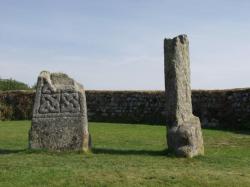
The Longstone
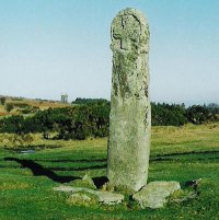 Known locally as 'Long Tom', the Longstone stands a few yards from the road, on Craddock Moor, south of Minions. This is just one of the dozens of similar stones scattered the length and breadth of the moor. Its position affords the visitor ample opportunity to stop and appreciate the atmosphere surrounding this weathered, cross-inscribed stone, 'Standing alone on a hill of storms'.
Rillaton Barrow
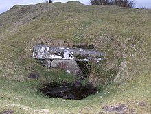 A very large Early Bronze Age barrow, two hundred yards north-east of 'The Hurlers'. The barrow is approximately thirty yards in diameter. An excavation by local miners in 1837 discovered a granite cyst set in its eastern edge. The site of the cist is still visible in the side of the barrow. The cist contained the remains of a human skeleton, beads, spear head, pottery and the 'Rillaton' Gold Cup, now held in the British Museum. A copy can be seen in the Royal Cornwall Museum, in Truro. Most notably, the burial contained, a bi-conical gold vessel, about three and a half inches high, with a handle attached with rivets. The cup resembles a late Neolithic (approx 2300 BC) ceramic beaker with corded decoration.
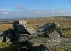
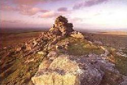
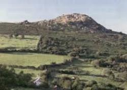
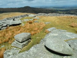
Rough Tor
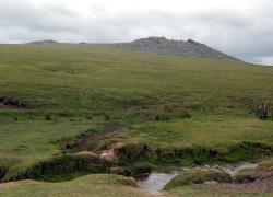 Owned by the National Trust, this is one feature of the moor which should remain unchanged for posterity. In the 19th-century the hill was known as Router and even into the late 20th century some locals used this pronunciation. At 1311 feet it is the second highest hill on the moor and is wonderfully remote and unspoilt and only one mile north-west of Brown Willy. The De Lank River rises nearby and flows between the two hills, Rough Tor and Little Rough Tor. The summit of the tor was once the site of a medieval chapel, which was built into the side of one of the cairns, and was dedicated to St. Michael. The chapel was recorded in the 14th century, and is the only known hilltop chapel on Bodmin Moor. As it overlooks an ancient trackway across the moor, it may have served as a guide for travellers. There are the remains of a Bronze Age settlements around the hill. Charlotte Dymond was murdered here in 1844 and a memorial to her stands somewhat forlornly at the foot of the slope. Her murderer Matthew Weeks was hanged in Bodmin Jail in front of a crowd of 20,000. Roughtor was presented to the nation in memory of those who lost their lives while serving in 43rd (Wessex) Division in the North West European campaign 1944-5. The Holy Well of St. Michael on the slopes of Rough Tor, was rediscovered and restored in 1994. In a programme shown in 2007 Channel 4's Time Team investigated a 500-metre cairn and the site of a Bronze Age village on the slopes of Rough Tor. Rough Tor features in Daphne du Maurier's novel Jamaica Inn.
Sharptor
 Physically one of the smallest tors when viewed from the moor itself, Sharptor is most spectacular when viewed from Henwood village. Easily accessible, but it still reaches 1066 feet, and is located about one mile north of Minions, it commands a breath-taking view of the whole of East Cornwall - and beyond. On a clear day it is possible to see the sea both to north and south. Originally known as Sharp Point Tor, it is distinguishable from many miles away.
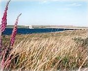
Siblyback Reservoir
 A man-made lake located about one mile west of Minions, the dam was completed in 1969. Covering 140 acres and well-stocked with fish, this is a popular place with anglers and boating enthusiasts, but it is rarely uncomfortably crowded. In winter the reservoir becomes a lonely part of the moor, providing a haven for a large variety of birds, some resident, others casual visitors. The overflow from the reservoir runs into the River Fowey just above Golitha Falls. Managed by the South West Lakes Trust. Now run as the Siblyback Lake Country Park.
Stowe's Pound
 An elongated hill, 1,250 feet high, located on the eastern edge of Bodmin Moor. Stowe's Hill is a prominent granite ridge located about one mile north of Minions. It is dominated by Stowe's Pound, a huge tor enclosure comprising two massive stone-walls. The smaller enclosure surrounds the tors at the southern end of the hill; the larger one encircles the rest of the ridge. At the southern end is a large, disused quarry, but the hill is best known as the site of the Cheesewring, the extraordinary granite formation that gave the quarry its name. Inside Stowe's Pound are two Bronze Age cairns, a stone round house and over 100 house platforms. The site is thought to be Neolithic or Bronze Age and connected with other settlements and ritual monuments in the vicinity.
Temple Church
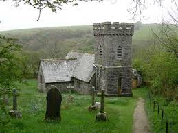 Once the Gretna Green of Cornwall, earning much of its income from marriages and burials. This settlement high on Bodmin Moor, just off the A30 road was founded by the Knights Templar in 1120 as a hospice for travellers. The little church built by the Knights fell into disrepair many years ago, but was re-built in 1883 on the original pattern as St. Catherine's by Silvanus Trevail. It is a stark little building, tucked away in a quiet valley but still serving its sparse community at Temple.
Tregarrick Tor
 A much under visited tor with excellent views over Siblyback Lake Country Park. Sitting at 1036 feet above sea level and not far from the Hurlers stone circles and the Cheesewring, it has a wonderfully remote atmosphere. Located about one mile west of Minions.
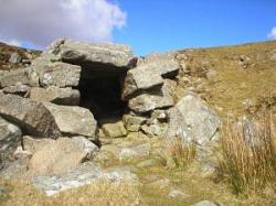
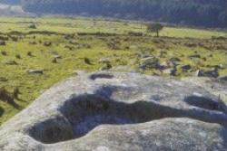
Trethevy Quoit
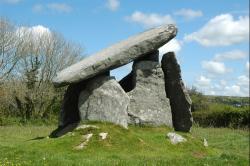 Close to Tremar, in St. Cleer parish, this is a well-preserved and impressive Chamber Tomb of the Megalithic period (3500 BC) and undoubtedly one of the finest in the county. Originally covered in earth to form a burial mound, this tomb would once have held the body of an important member of a primitive and superstitious community. Also known as King Arthur's Quoit.
Trewortha Bronze Age Farm
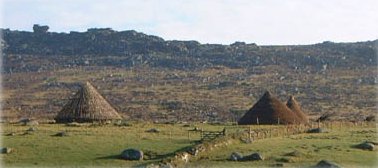 The Bronze Age Village at Trewortha is attached to the Trewortha Farm Centre near North Hill. It consists of Bronze Age roundhouse reconstructions on privately owned land, used for education purposes. It sits in the valley between Kilmar Tor and Trewortha Tor.
Carnglaze Slate Caverns Jamaica Inn Wesley Cottage Beast of Bodmin The Caradon Trail Crowdy Reservoir
Colliford Lake Dobwalls Family Adventure Park Sterts Theatre and Arts Centre Siblyback Lake Country Park
Altarnun Blisland Bodmin Bolventor Cardinham Woods Launceston Liskeard Minions North Hill Temple
Cardinham St. Breward St. Neot St. Cleer Cornwall at War Museum Davidstow Moor RAF Memorial Museum
Ancient Sites in Cornwall The Copper Trail Cornwall's History Mining in Cornwall Horse Riding in Cornwall

