Family beach resort
Web: www.mawganporth.info
Web: www.visitcornwall.com/destinations/mawgan-porth
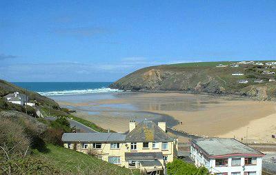
Large sandy beach and settlement situated north of Watergate Bay, four miles north of Newquay on the B3276, right on the Atlantic Ocean coast.
Mawgan Porth is in the civil parish of Mawgan-in-Pydar at the seaward end of the Vale of Lanherne (or Vale of Mawgan) where the River Menalhyl discharges into the sea. The hamlet consists of a pub, a general store, two surfing schools and several hotels, guest houses and caravan parks.
The sandy beach, backed by dunes with cliffs at each end, is quality-assessed and supervised by lifeguards during the summer. It is a popular surfing location. The South West Coast Path passes behind the beach and the area attracts many holiday-makers.
In the years 1949-1952, 1954 and 1974, archaeological excavations revealed a settlement comprising three groups of buildings ('courtyard houses') and a burial ground dating from around 850-1050. Finds included pottery and stone artefacts.
Mawgan Porth is recorded as Porthglyvyan in 1334, Cornish for cove of the little wooded valley river, and later as Porthmaugan in 1755, Cornish for cove of St. Mawgan.
On Sunday 26th October 2014 three surfers, two men and a woman, died after getting into difficulty whilst surfing in the sea off Mawgan Porth beach. Four children in the same group were saved.
The German sculptor Faust Lang (1887–1973) lived in Mawgan Porth from 1936 to 1949.
Newquay Bedruthan Steps The Coastal Footpath Watergate Bay Lanherne House
St. Columb Major Cornwall's Beaches Cornwall Karting Japanese Garden