
From Padstow, PL28 8BW to Fowey PL23 1HY
Tel: (0300) 1234 202
Email: countryside@cormacltd.co.uk
Web: www.cornwall.gov.uk/environment/countryside/cycle-routes-and-trails/the-saints-trail
Web: www.visitcornwall.com/things-to-do/walking/the-saint-s-way
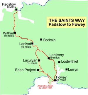
From coast to coast in mid Cornwall
The Saints' Way is an attractive middle distance route of just under thirty miles which crosses the county of Cornwall, coast to coast, from Padstow in the north to Fowey in the south. It passes from one major estuary to another, follows river valleys and traverses the granite spine of the county. It joins a number of religious sites which have connections with Cornish Saints and Holy men and parts of the route are of very ancient origin. The route follows existing public rights of way and accords as closely as these rights allow, with a route which could have been used in ancient times to cross the county. The Saints' Way, in historical context, should therefore be regarded as a route which may, in parts, have been used by the Saints, but which certainly offers the opportunity to appreciate the religious significance of the area.
Apart from its historic interest, the route passes through areas of attractive scenery and settlements whose location, away from major 20th century routes, has slowed the effect of development. The uplands of St. Breock Downs and Helman Tor provide wide ranging views across the tapestry of landscape from the "White Alps" of the china clay area around St. Austell to stretches of untouched moorland. The lush river valleys contrast with the bracing upland heights, and the dramatic Atlantic coastline of the north with the more gentle scenery of the south coast.
The Saints' Way project was conceived, in 1984, by Cliff Townes and Alf Fookes from Luxulyan. They uncovered a number of elaborate granite stiles near the village and interested the Cooperative Retail Services Community Project in carrying out clearance work in the parish. This led to the identification of a route from the north coast to the south coast which was formally opened in May 1986.
The route is described from north to south and, at Helman Tor, travellers have the option of either going through Luxulyan, Tywardreath and Polmear or keeping closer to the Fowey river via Lanlivery, Milltown and Golant. There is little difference in length between the two routes. The Lanlivery route passes through less populated areas, but the ascent from Polmear gives wide ranging views across the sweep of St. Austell Bay.
The route starts at the south door of Padstow Parish Church. The churchyard approximates to the site of a monastic enclosure within which Petroc and his followers built their monastery in about the 6th century. The medieval four hole cross by the door and the base of another, are a reminder that the site was important after the Norman Conquest.
The route leaves the churchyard by way of the Lych gate and passes along Hill Street - in fact a wooded path. At the junction with New Street it continues straight across into Dennis Road and down along Dennis Lane past the boating lake.
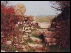
The obelisk on Dennis Hill can be seen to the left and, by the boating lake, the embankment along which the London and South Western Railway ran to its most westerly destination - Padstow. The railway was closed in 1967 and the route from Padstow through Wadebridge to Bodmin and Wenford Bridge is now a pedestrian and cycle way - The Camel Trail.
The route turns left beyond the boating lake then right uphill after 30 yards and continues with the field hedge to the right. At the top of the hill it crosses a stile and continues downhill, with the field hedge to the left, to the next stile. The path then bears slightly right to the light woodland and down to the footbridge across Trerethern Creek.
Trerethern, which is situated upstream (and to which there is no public right of way) is a typical early medieval settlement, small, isolated from other dwellings, sheltered and with a good water supply.
The path crosses a narrow neck of land and follows the field edges along Little Petherick Creek. On the opposite side of this creek is Seamills. This was a tidal mill, worked by impounding the waters at high tide and releasing them, as the tide receded, through sluices to power the mill wheels. The wall impounding the water can still be clearly seen at low water.
The path then descends the gorse covered slopes to Credis Creek, crosses the creek and follows an old sanding track (hedged to the left) up the hill.
The fields at the head of the creek are the site of a former silver, lead and copper mine which employed 40 people in the early part of the 19th century. The stream is the parish boundary and the route crosses from Padstow Town to the parish of Little Petherick.
Where the sanding track emerges onto the open field, the route bears to the left to the turn in the field boundary ahead and then continues, with the boundary to the right, to the stile into St. Mary's woods. The path continues through the woods and down steps to a track into Little Petherick.
At the point at which the path emerges onto the track, the home of Athelstan Riley, a prominent leader of the Anglo-Catholic movement in the early 19th century, can be seen to the right. The Church of Little Petherick is a few yards to the right of the point at which the track meets the county road. It is probable that the ancient route came down the steep hillside, to the back of the Church, having kept to higher ground from Dennis Hill.
The route turns to the left, following the county road across the bridge into St. Issey parish and continues uphill. After 200 yards the route leaves the road, crossing the slate stile on the right into Mellingey Fields. The path runs at a slight angle downhill towards the stream, then cuts diagonally across two fields up towards the road and the hamlet of Mellingey. The route then bears to the right along the road.
Mellingey Mill is now used as a willow workshop and willows, for basket making, can be seen growing in surrounding fields. The house beside the mill was occupied by a Doctor Marley, a friend of the author Charles Dickens. His name was borrowed for one of the characters in "A Christmas Carol".
The route continues along the county road, bearing slightly to the right at the junction after three quarters of a mile. The route continues a hundred yards or so into the hamlet of Trenance and then turns to the left, where the road bears right, along the track known as Blable Lane.
The village on the opposite side of the valley, along this road section is St. Issey, which has both a public house (The Ring O' Bells) and a shop. On the right hand side of the point at which the road bears sharply left, about 500 yards from Mellingey, the outline of the Iron Age settlement known as Trenance Rounds can be seen.
The path continues along the track, across the field at its end and down the hillside to the Blable Stream. The route crosses the footbridge and continues across the next two fields, along the lane to the side of the farmstead and turns right onto the county road.
Blable farm is an ancient settlement, although the present house dates mainly from the 19th century. The name Blable is derived from "Blyth- pol" meaning "wolf pit".
The route passes Blable farm and turns left at the T junction. At the A39 it turns left, crosses the road and goes down the entrance to West Park farm (about 50 yards from the junction). The road forms the boundary with St. Breock parish. The path continues along the farm track and climbs slowly onto St. Breock Downs, the highest non-granite uplands in the county, finally coming out onto Pawtonsprings farm lane, and so to St. Breock Beacon.
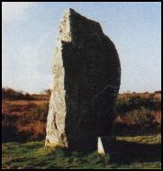
The ascending route passes the site of Pawton Mine and the sites of a number of tumuli, before reaching St. Breock Beacon which, at 700 feet above sea level, is the highest point on the route. The prehistoric standing stone, the St. Breock Longstone, is looked after by English Heritage. Hereabouts, on 4th June - St. Petroc's day - the priests and inhabitants of the parishes of Padstow, Little Petherick and Bodmin would meet to commemorate their patron saint. There are far reaching views from this point. To the north, from which direction walkers have come, lies the Camel Estuary; to the east stretches Bodmin Moor and Caradon Hill (with its TV mast); to the south the "White Alps" of the china clay district around St. Austell can be seen and westwards the Iron Age hill fort of Castle an Dinas.
From St. Breock the Way continues along to its junction with the county road where it turns left. The route takes the second turning to the right, passing St. Breock Downs farm and the gates of Hustyn's Health Hydro. The road bears to the right by a new dwelling and after a further 200 yards, where the road goes left, the route continues straight on, down a broad, green lane. The route continues, almost in a straight line, over the shoulder of the hill and down into the small valley which leads to Trequstick. It then turns right along the county road and, 100 yards after a right angled bend, turns left down a lane which forms the boundary with Withiel Parish. It crosses the two footbridges and continues uphill through the yard of Blackhay Farm, bearing left at Withiel Church to reach the road.
The Church, dedicated to St. Clement, is medieval. Beyond the wall is the Old Rectory, built in about 1520 by Prior Vyvyan, the last prior of St. Petroc's Priory at Bodmin before the Dissolution.
The route turns right across the front of the Church then, after 80 yards, left across the fields of Churchtown Farm and down the hillside to the area known locally as Lanzota, possibly an early medieval site. From the stile and footbridge at the foot of the valley, the path continues diagonally uphill and to the right and continues with the top field hedge to the left. At the next gate the path bears to the left, crossing diagonally to the stone stile into Withielgoose Lane.
Withielgoose Manor, to the North East, is mentioned in the Domesday Book. At the end of Withielgoose Lane the route turns to the left and follows the road to Tremore Bridge. Just before the bridge, the former Withiel smithy can be seen on the right. The road is part of the medieval route from Bodmin (at that time an ecclesiastical and commercial centre) to St. Columb Major (then an important market town). The stream forms the boundary between Withiel and Lanivet parishes and is a tributary of the Camel. Upstream, tin streaming and iron mining was carried out up to the mid 19th century.
From the bridge the route continues uphill, past Tremore Manor to Tremore crossroads where a well preserved medieval cross can be seen. The route turns to the right, towards Higher Woodley and, where the road turns sharply to the right in this hamlet, continues straight on across three fields to a lane and then on to the county road (Cadwyn Lane). The route continues straight on, descending across Woodley crossroads and down Clann Lane into Lanivet.
The road which is crossed at Woodley was previously the main A30 route from Bodmin to the west. This was replaced by the road through Lanivet which, in its turn, has been superseded by the Bodmin by-pass. Lanivet was an important early Christian centre. In the churchyard are several elaborately carved medieval crosses and a 7th century inscribed memorial stone. Today the village can offer travellers shops, cafes and a pub (The Lanivet Inn).
The route crosses the main road through Lanivet and continues up Rectory Road, right and under the new by-pass, then first left at Reperry Cross. The cross is situated beside the pre-turnpike route which led from Bodmin to St. Austell. Reperry itself is an ancient farmstead half a mile to the west.
The route continues below the Reperry Ridge to the cross at St. Ingunger, another important early Christian settlement. There it turns right, in the direction of Fenton Pits. The winding road continues downhill through Trebell Green and then bends sharply right along the valley bottom. The next turning to the left confronts travellers with a choice: turning left, the route passes Helman Tor, Lanlivery, Milltown and Golant; continuing straight on, the route to Fowey passes Luxulyan, Tywardreath and Polmear. This road junction also forms the boundary between Lanivet and Lanlivery parishes.
The route climbs from Helman Tor Gate to the Tor itself, at 680 feet the second highest point on the Way.
On the summit are the tumbled remains of a 6,000 year old Neolithic enclosure. From the Tor, in good weather conditions, the start and the end of the Way can be seen; the Atlantic coast to the north and that of the Channel to the south. To the east is the narrow valley of the River Glynn and, on a clear day, the hills of Dartmoor can be seen. To the west is Roche Rock with its hermitage and chapel of St. Michael (licensed 1409) and beyond that again, St. Agnes Beacon (the rounded hump between the rock and the Church tower).
The route follows the road along the ridge, until it meets the surfaced road to Lanlivery. This route, along the ridgeway, is probably part of a prehistoric route between the north and south coasts which continued in use through the dark ages and medieval times. In the first field, beyond Helman Tor, a Logan Stone can be seen and a little further on, on the same side, a triangular plot was the original site of Bodwen cross, presently sited in Lanhydrock graveyard. Just to the left of the route, before it meets the county road to Lanlivery, are the ruins of Menawink, whose possible definition is "windy hill".
At the junction with the road to Lanlivery the route turns to the left and goes straight on across the crossroads at Lower Pennant and into Lanlivery village. The route passes the Church, whose magnificent granite tower dominates the surrounding countryside. The Crown Inn, to the right, is a building of medieval longhouse construction.
The route ignores the next turning to the right and takes the next left hand turn, (signposted Lostwithiel). Follow the road to Pelyntor Cottage. Just after the cottage the Way takes the steps to the left, uphill and follows the field hedge to a gate/stile. The route then follows the hedge along the hill, over the stile and right, along the county road to No Man's Land.
Should it be desired to make a diversion to visit the charter town of Lostwithiel, the path opposite avoids a busy section of the A390.
From the medieval cross at No Man's Land, the Way continues left, downhill towards Liskeard before taking the first turning to the right and then right again after about 200 yards, down the farm lane. This section of the route can, at times, be very muddy and there is an alternative way by continuing along the road and turning right at the T junction.
This hedged route is known as Huntingdon Lane and the narrow lower section is particularly attractive, plunging steeply down the hillside towards Castle. Despite its narrowness, grooves in the rocky sides testify to the fact that it was once well used by carts.
The Way turns right onto the metalled road at the foot of Huntingdon Lane and keeps to the left at the next junction, heading towards the hamlet of Milltown. The route continues downhill and under the railway bridge which carries the main Paddington-Penzance line. It passes between two granite pillars which mark the boundary of St. Sampson parish and continues along the road for the next mile or so before turning to the left, up the hillside, towards Golant.
Along this stretch the route passes Lantyan, traditionally the residence of King Mark. Castle Dore, an Iron Age hill fort, mistakenly attributed to King Mark, lies to the west, on the ridge between the Fowey and Par estuaries. Close by on the Fowey road is the famous Tristan stone, an early, inscribed memorial stone. The route parallels the Fowey estuary and there are glimpses of the estuary as well as the hills and valleys of the parishes of St. Winnow and St. Veep.
The path climbs the hillside, crossing the track to Penquite (which is now a Youth Hostel) and continues diagonally to the right, across a large field, to the brow of the hill. It continues across the stone stile in the hedge to the right, before following the field hedge down to a gate onto the metalled road, then left towards the Church of St. Sampson.
The Holy well of St. Sampson can be seen by the Church porch. St. Sampson travelled from Padstow, in the 6th century, en-route to Brittany.
The Way continues down the steep School Hill into Golant, across the crossroads and past the Post Office. It then turns right by "Hendra", through a pair of granite gateposts and along the track which leads out onto Golant Downs.
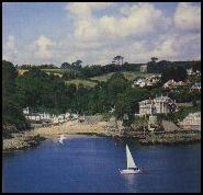
Golant has retained its railway link to Lostwithiel, though this is now only used for the transport of china clay to Fowey docks. The village is a popular yachting centre and has a pub called The Fishermans Arms. The Downs give an excellent view across to the Caradon side of the estuary and on the opposite side is Penpoll Pill, upstream of which was the former monastic settlement of St. Cadix. The path carries on across the Downs and dips down towards Bodmin Pill, across stepping stones into Fowey parish.
A road formerly led up the valley from the building at Bodmin Pill (now known as Sawmills) and trade was carried on from this point. The building is now used as a recording studio and can only be reached by water or by footpath.
From the stepping stones the route continues to the right, through the woodland, turning uphill to the fields of Penventinue Farm. Above the wood, the path meets a field hedge and continues with this to its right, up to the metalled road. The Way turns left at the road and crosses the former Par to Fowey branch railway line which has now been converted to a road, For the transport of china clay. At the T junction it winds downhill, past the landing point for the Bodinnick Ferry, to the junction with Bull Hill (immediately before the Post Office). Bull Hill is a footpath which takes walkers above the older part of the town and down to the Church of St. Fimbarrus and the end of the Saints' Way.
St. Fimbarrus crossed from Ireland in the 7th century and founded a Christian cell here on his way to Brittany and Rome. Now, thirteen centuries later, walkers follow a broadly similar route.
The route continues along the road from the foot of Helman Tor, bearing left at Gunwen Chapel and taking the next turning right. After about 100 yards the Way bears right, following the road towards Corgee Farm. Having passed the farm and the next - Tredinnick - it turns left, off the metalled road, down a track.
Breney Common is a nature reserve owned by the Cornwall Trust for Nature Conservation. The farms, through which the route passes, are notable in having retained many of the old buildings which were typical of this semi moorland area.
The path continues down the lane towards Trenince, crosses a stile to the right after a couple of hundred yards and continues across the fields to the valley bottom. It enters the scrub land to the right and then crosses a stream by means of a combined granite footbridge and stile. The route follows the stream then winds to the right to follow a hedge below the cultivated fields to the right. A number of notable granite stiles are crossed before the path comes out into open fields. The path then climbs, with a hedge to its left, until it crosses a further granite stile onto the road to Luxulyan Quarry.
This particular section of the Way is interesting for a number of reasons. The stiles are particularly elaborate and there is a section of cobbled path along the valley bottom. It was here that the concept of the Saints' Way was conceived, when Cliff Townes and Alf Fooks walked this (then heavily overgrown) route.
From the road to the quarry the path continues across the green triangle opposite, down the road and up to Luxulyan village by the Church.
The route passes an ancient well which can be seen at the side of the road. The Church itself has an 11th century font and the Lord's Prayer translated into Cornish as well as many other interesting features. Opposite the south porch is the grave of Silvanus Trevail, a local architect, who designed many primary schools and other public buildings in Cornwall.
From the Church in Luxulyan the path crosses the road and goes down the wide track at the side of the Post Office, over a granite stile by the former primary school and across the Par to Newquay branch railway line, here running in a cutting. It then runs diagonally downhill across three fields.
The track at the bottom of the valley is part of the former railway line which ran across the well known Treffry Viaduct, further down the Luxulyan Valley. Built in 1839 the viaduct is interesting in the fact that it combined the purposes of horse tramway, viaduct and aqueduct.
The route runs, with the old railway track to the left, down steps and then right, down another hedged track, over a granite stile and across a bridge. The stream which runs beneath this bridge was diverted by Treffry and is the watercourse which runs through the aqueduct.
The Way passes through woodland and then ascends to open fields. With the field hedge to the right, the path crosses four fields before coming to the short lane leading to Trevanny farm.
Adjacent to the first stile on this stretch is a stone bearing the initials "S C". A possible explanation of this is that the initials stand for Saint Cyor. What is certain is that this is a path which leads from Luxulyan Church to St. Blazey.
From the farmyard the route continues to the right, down a broad hedged lane and bears slightly to the right at its end, passing through light woodland before coming out into a field and continuing straight uphill to the metalled road.
To the west, on the hill, is Methrose, a medieval manor house where John Wesley stayed many times on his evangelising tours of the Duchy.
The Way crosses the metalled road and takes the surfaced drive towards Prideaux Farm, continues slightly uphill to the right, through the yard and then, about 50 yards from the last building, turns left across a stile into a field. The path continues, with the field hedge to the left, to a further stile into Nanscawen fields.
To the left of this field hedge are the remains of the Iron Age Prideaux Castle hill fort. Please ask permission of the farmer if you wish to inspect the site. As the route turns round the shoulder of the hill, towards Nanscawen, the sweep of St. Austell Bay comes into view.
The route continues along the top of the field above Nanscawen, with the woods to the left. At the next stile, the path turns sharply to the right, downhill through the woodland, then, after a further sharp left then right hand turn, joins the metalled road. From here it follows the road down to a T junction and the parish boundary with St. Blazey. Carrying on to the left, downhill, the Way meets the main A390.
Forth an Syns does not go through the main part of St. Blazey. Travellers should turn to the right if they wish to take advantage of the shops and other facilities available. The Church lies a few hundred yards in this direction and it is noteworthy that the sea came up almost to its walls 150 years ago but has now receded two miles.
The Way turns to the left at the A390 junction, once again crossing the Par to Newquay branch line, leaving St. Blazey parish and entering Tywardreath. The route turns right, off the main road, beyond the filling station and at the end of a row of former miners cottages, climbs the hillside towards Kilhallon. Where the path meets the metalled road it turns to the left and continues straight across the next crossroads, continuing almost on a contour along the hillside. About 800 yards after the crossroads, the Way turns right downhill and towards Tywardreath.
The area to the north of the route, at this point, was extensively mined; many of the spoil heaps still remaining. The area to the south, towards Tywardreath, is the setting of Daphne du Maurier's book "The House on the Strand".
The route carries on down to the valley floor, under the Paddington-Penzance railway line and enters Tywardreath by way of Marsh Lane. The Way goes straight across the road junction in the village, passing in front of the Church of St. Andrew.
Turning to the right, down Well Street, it continues over the top of the hill and down to the road junction at Polmear. Having crossed the road the route passes under the former Par to Fowey branch line, now converted into a private road and turns left after the under-pass to join the South Cornwall Coast Path at Par beside The Ship Inn. The Way goes straight on when the Coast Path turns to the right after 200 yards and when open fields are reached it goes diagonally to the left, uphill across two fields, to meet the main Fowey road near the top of Polmear Hill.
PLEASE TAKE PARTICULAR CARE AS THE VISABILITY AT THIS JUNCTION IS RESTRICTED AND THE ROAD IS FREQUENTLY BUSY.
The views on the ascent from Polmear are wide ranging; seaward, the sweep of St. Austell Bay to Black Head and beyond and inland, to aptly named Trenython Manor "the house in the gorse".
After 200 yards the route leaves the main road on a wide bend, following the road to the right, signposted Polkerris.
The slate hung house to the right is Kilmarth (meaning 'horse's back'). It was the last home of Daphne du Maurier and this peninsula was the setting for many of her novels.
The Way continues past the turning for Polkerris and turns left, just before the Church at Tregaminion, down the lane towards Tregaminion Farm.
One of the medieval crosses in this churchyard formerly stood on the route of the Saint's Way between Lanlivery and St. Sampson.
The route continues downhill, turning to the right by the farmhouse, then turning to the left after another 30 yards, passing through a gate to the left and continuing straight down the field towards a stream and the ruins of a building. It then goes over a stile and bears to the right, across the shoulder of the hill, down and across a small stream. It then follows a hedge uphill (with the hedge to the right) and climbs the hill to Trenant and the parish boundary of Fowey. The route continues almost straight on, just below Trenant guest house, on the lower side of a field boundary, to the entry to Lankelly Woods.
To the right, along this stretch, the Gribbin daymarker can be seen. This serves to indicate to sailors the entrance to Fowey Harbour.
The Way descends on a path through the woods. It passes under an arched bridge, crosses a stream and ascends to Lankelly Farm where it turns right onto the road.
The arched bridge carries the carriage drive to Menabilly, the ancestral home of the Rashleigh family and, for many years, Daphne du Maurier's home. This part of the path is an old trading route connecting Fowey and Polkerris. The name Lankelly means "sacred enclosure in the grove" and emphasises the religious connections of the area.
The route continues along the metalled road for 300 yards and then takes the road turning to the left. After a further 250 yards the Way turns to the right (marked National Trust) down Love Lane, a former packhorse route, to Readymoney Cove. The route then goes left along the metalled road, parallel to the river and through the narrow streets of Fowey to the Church of St. Fimbarrus and the end of Forth an Syns.


Cornwall's Patron Saints Padstow Fowey The Bodmin Way Walks and Walking in Cornwall