Old mining village on the southern edge of the moor
One of the moorland villages whose population increased so dramatically when copper was discovered at nearby Caradon Hill in 1837. It was the centre of a parish of rough, tough miners until they came under the sobering influence of Methodism. There is still a large Methodist chapel here, but others are now dwelling houses.
The village lies two miles north of Liskeard on the southern edge of Bodmin Moor and is accessed from a road off the B3254. The population of the village at the 2011 census was 3,339.
Like nearby Minions, this parish on the southern slopes of Bodmin Moor was overwhelmed, and transformed, by a copper mining boom in the mid 19th century which has been compared, in its intensity and in its social and economic repercussions, to the North American gold rush. On Saturday nights after pay-day, the populous villages of Caradon Town, Pensilva, Minions and Crows Nest were crowded with men, and resembled in character the mining camps of Colorado and the Far West.
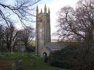
The village boasts an attractive 15th century church dedicated to Saint Clarus, with a number of Norman features and a fine tower 97 feet tall and contains a ring of six bells, it also has two pubs, an excellent Farm Shop, and a Post Office & General Store/Newsagents opposite the fine parish church.
Also in the village is St. Cleer holy well, in a beautiful 15th century building; there used to be a total immersion (or 'bowssening') pool here which was used for the attempted cure of the insane.
The ancient sites of King Doniert's Stone and Trethevy Quoit are both within half a mile of the village.
Bodmin Moor Liskeard Minions St. Neot Siblyback Lake Country Park
The Copper Trail The Caradon Trail