

Family beach with spectacular cliffs
Web: www.nationaltrust.org.uk/visit/cornwall/boscastle/crackington-cracker-walk
Web: www.visitcornwall.com/things-to-do/beaches/crackington-haven-beach
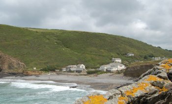
Whichever direction you approach Crackington Haven, it is located seven miles south-southwest of Bude and four miles north-northeast of Boscastle. and about two miles west of the A39, the views are really spectacular. Inevitably there has been limited development over the years, but this has mostly been done in a tasteful way and the scenery in the beach area and surrounding majestic cliffs is almost unrivalled. Only the road separates the sea from a couple of beach shops, a handful of houses, a public house with excellent restaurant, a hotel and a cafe. Almost unlimited car parking space makes this a good base for those who enjoy walking.
Coastal vessels used to run up on the beach here to land limestone and coal and load slate from the local quarries - a hazardous undertaking in any weather on this exposed coast but the one to which the hamlet of Crackington Haven owes its existence. The slate trade went into a steep decline and has long since ceased but the pretty little haven remains.
After the railways reached the district in 1893 the village could be reached more easily so holiday-making became more common.
The parish of St. Gennys prides itself on the excellence of its public paths, and this is due in no small way to the help of the Heritage Coast Service and the National Trust - the latter owning and controlling most of the cliff and adjacent farm land. To the north over the 430 foot Penkenna Point lies the 15th century, St. Gennys church, with its breathtaking views towards Bude, Morwenstow and Lundy Island. The churchyard is also the last resting place of shipwrecked mariners, and perhaps a few smugglers ! (The old name for those from St. Gennys was 'Wreckers & Wrestlers' ). A mile or so inland are the well thought out Treworgie Barton Woodland Trails.
To the south, the North Cornwall Coast Path traverses the highest cliff in England - High Cliff at well over 700 feet. Thomas Hardy and his first wife Emma used to walk here. St. Juliot Church is only about two miles inland. A little of the 'Poldark' series was filmed in the area. For those who like remote beaches, there are few that rival Strangles and Rusey - world away from civilisation. Away from the coast are tranquil woodland paths with tinkling streams, and sunny meadows, and perhaps the fleeting glimpse of deer. Many of the farms can provide meals and accommodation, and Trevigue on the cliffs near Strangles is nationally acclaimed. You can also find camping, caravanning, private guest houses, self catering and farm bed and breakfast. Of course the summer sun, the sand and the surf are attractive, but many come back for the relative peace of winter with its salt laden Atlantic gales and days of mist and rain - days of smugglers and wreckers - and ghosts of Hardy & Poldark.
Crackington Haven was badly affected in 2004 by the flood that damaged several other villages, including Boscastle. The road bridge across the stream, several homes and pub were damaged by flood-water.
Boscastle Bude The Coastal Footpath Tintagel Widemouth Bay