Only major estuary on the north coast
Web: www.visitcornwall.com/things-to-do/nature-and-wildlife/camel-estuary-aonb-section
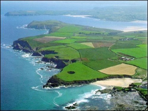
This unspoilt part of Cornwall's north coast shows the expanse of the Camel Estuary where it reaches the Atlantic Ocean in this view looking north east. The sands which stretch between the two headlands are known invitingly as The Doom Bar, the site of many a shipwreck.
The further headland is Pentire Point and below it can be seen the village and beach at Polzeath. The nearer headland is Stepper Point with its Coastwatch Institution lookout and daymark built in 1831 to warn shipping. The beach at the bottom of the 'photo is Trevone. The strange depression in the cliff top is known as Round Hole for some reason.
The Camel Estuary, with its contrasts of remote, rugged landscape, long stretches of sandy beaches and mild climate, is rightly claimed as one of, if not the major attraction on the North Cornish coast. The tidal waters of the estuary stretch from the mouth of the estuary some five miles south towards Wadebridge and up to a mile wide between Rock and Padstow. This large inland area of calmer waters is protected from the Atlantic ocean by Stepper Point, Pentire and a sand bar at the mouth of the estuary, giving ideal conditions for all varieties of water sports.
Padstow Polzeath Rock The River Camel Trevose Head St. Merryn Wadebridge
The Coastal Footpath Trevibban Mill The Camel Trail Cornwall's Beaches