

Web: www.cornwallriversproject.org.uk
Web: www.wrt.org.uk
Once the lifelines of the county
| The Allen | The Camel | The De Lank | The Fal | The Fowey | The Gannel | The Hayle | The Helford | The Inny |
| The Lerryn | The Looe | The Lynher | The Ottery | The Red | The St. Austell | The Seaton | The Tamar | The Tiddy |
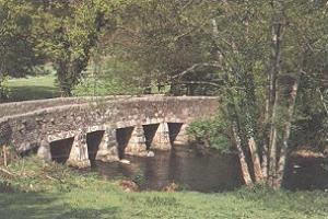
Cornwall has some fine and interesting rivers most of which flow through farm and woodland, past mills, over huge boulders and under ancient stone bridges, but all end in beautiful estuaries.
The River Allen is one of two rivers in Cornwall which share this name. In this case the name is the result of a mistake made in 1888 by Ordnance Survey, replacing the name Layne with Allen which is the old name for the lower reaches of the Camel. The other River Allen runs through Truro. It is a major tributary of the River Camel. It springs north-east of Camelford and flows south-west through the Allen Valley passing St. Teath and St. Kew Highway to join the Camel at Sladesbridge.near Wadebridge.
Starting with its source at Hendraburnick Down on the northern edge of Bodmin Moor, the Camel turns south passing near to St. Breward and flows under several bridges, Slaughterbridge, Gam, Wenfordbridge, Poley's Bridge and Helland to name a few on its way down the western edge of the moor from Camelford, to near Bodmin at Nanstallon, having been joined by the De Lank near Blisland and crossed by Dunmere Bridge carrying the A389. From here, after a change of direction to north-west, the river makes its way on, passing Camel Valley Vineyards to Wadebridge, where it is crossed by a long seventeen arched bridge. Now a wide tidal estuary, followed by the former railway which is now used as the Camel Trail and flanked by sand dunes, it weaves its way past Rock and Padstow joined by a ferry then on past Polzeath, and between Pentire and Stepper points, before crossing the infamous Doom Bar into the Atlantic Ocean, a journey of about 25 miles.
The De Lank River features some of the most pristine habitats in Cornwall with outstanding water quality and a wealth of wildlife. A walk along the De Lank River still reveals many remains of old tin mining stream-works. These can be found along much of its Bodmin Moor stretches which were originally worked for tin lodes contained in its bed, banks and silts. The source of the De Lank is high up on the northern slopes of Brown Willy not far from the source of the River Fowey which runs off its eastern side. The young river passes on the eastern side of Garrow Tor before passing by the quarries of Hantergantick, the river drops steeply off the moor passing the hamlet of Bradford and Delford Bridge before joining the River Camel near to Penpont, about ten miles from its source. Many rare species of plant and animal life are found in and around the River including Otters and Kingfishers.
With its source in the heart of Cornwall, on Goss Moor near Indian Queens, the Fal as a small stream flows south past the villages of St. Stephen, Grampound and Tregony, to which point it used to be navigable many years ago. Then on through some woods before opening out into a tidal estuary near Ruan Lanihorne. Now meandering around below the estates near St. Michael Penkevil where it is joined by the river coming down from Truro, soon after which it is crossed by the King Harry ferry, and then past the gardens at Trelissick. Here the river Fal joins into Carrick Roads before passing Falmouth and St. Mawes on its way out into the English channel overlooked by St. Anthony Head on the tip of the Roseland Peninsula.
With its source high on the wilds of Bodmin Moor near the famous Jamaica Inn, the Fowey flows south under the A30 at Palmers bridge and then across the moor, down through the Fowey valley, joined by the water from Siblyback Reservoir, under Draynes Bridge built in 1876 and eventually dropping down over the boulders in the woods at Golitha falls. Then passing under Treverbyn Bridge, which was built in 1413 and replaced in 1929 by a new bridge a few yards downstream, continuing on, meandering through meadows down past Ashford Bridge and eventually to Doublebois Bridge which carries the A38 road. The river then turns west and runs along the wooded Glynn valley, soon joined by another moorland stream, the St. Neot which is fed from Colliford Lake, which in turn is fed from Dozmary Pool. The River Warleggan rises near Temple and flows south to join the Fowey just south of Pantersbridge near St. Neot. Then after about five miles, south of Bodmin the river makes another turn, this time to the south, past the great estate of Lanhydrock, under Respryn bridge, and then down a few more miles to Lostwithiel, overlooked by Restormel Castle. Here the river is crossed by Lostwithiel Bridge built as long ago as 1290, the lowest bridge on the river. From here down it becomes more of a tidal estuary, joined by a river that starts on the Boconnoc estate and flows down through Lerryn, and then on past the sleepy village of Golant before passing Boddinnick, Fowey and Polruan with their ferrys, and finally out into the English Channel.
An eight mile river which rises in the village of Indian Queens in mid Cornwall. It flows north under Trevemper Bridge and becomes a tidal estuary, the Gannel, that divides the town of Newquay from the village of Crantock and joins the Celtic Sea after passing the Gannel estuary. The Newlyn Downs form part of the catchment area of the river. The principle tributary of the Gannel is the Benny Stream. Since January 2016 the Gannel estuary, as far as the tidal limit, has been part of the Newquay and the Gannel Marine Conservation Zone. A shipbuilding industry once existed at Tregunnel on the north shore of the estuary, where, from 1858 to 1881, Thomas and John Clemens built ten schooners. At Penpol Creek a ruined lime kiln can be found. Limestone and coal were transported here in the past by barge. Until late in the 20th century the mouth of the Gannel was used by shipping until the silting up of the narrow channel and the development of Newquay harbour. In 2014, storms damaged a wall that altered the course of the river, so that it now flows across Crantock beach. A seasonal ferry runs from the Fern Pit across to Crantock beach.
The River Hayle is approx twelve miles long and its source is south-west of Crowan, near Helston. It runs west for approx five miles (which brings the river to within three miles of the south coast at Marazion). It then flows through a steep wooded valley north of the granite high ground at Trescowe Common, formerly a mining area, before turning abruptly north near the hamlet of Relubbus. It then follows a northerly course for the remaining six miles, passing St. Erth and the salt marsh of Lelant before reaching the Atlantic ocean at Hayle harbour.
Rising a couple of miles north of Gweek near Helston as a tiny stream between the fields, the Helford becomes a quiet tidal creek from here down, almost making an island of the Lizard Peninsula. Gweek used to be a working shipyard, but is now well known for the seal sanctuary. It continues on down through a flooded, wooded valley, past Trelowarren and joined by several other smaller creeks, amongst them Frenchmans creek made famous by Daphne du Maurier, and the Duchy Oyster Farm on the creek near Port Navas. Then on past Helford village on the right bank joined by a ferry to Helford Passage on the other bank. Opening out into a wide estuary with Glendurgan and Trebah gardens on the left and the tiny St. Anthony church on Dennis Head nestling in a headland on the right where it finally meets the sea, south of Falmouth.
Another twenty mile long river that drains the northern part of Bodmin Moor near Davidstow. Flowing quietly down the valley past St. Clether, Laneast and Trewen before it passes under the A30 at Polyphant where it is joined by Penpont Water which flows down from Altarnun. Continuing on in a south-easterly direction eventually reaching Wooda Bridge on the Callington to Launceston Road. Then passing Bealsmill and dropping through some woods it joins the River Tamar.
The River Lerryn is a tributary of the River Fowey. The Lerryn is the largest of the tributaries which enter the estuary of the Fowey. The river is tidal up to the village of Lerryn. The landscape of the Lerryn catchment is rural and includes heathland, moorland and rough pasture in the upper reaches and broadleaf, coniferous and mixed plantation woodland in the lower. The Lerryn rises at Fairy Cross on the southern slopes of Bodmin Moor and flows south-west until it enters the Fowey estuary. The name of the river is Cornish; the earliest record of it is as "Leryan" and "Lerion" in 1289. In modern Cornish its name would be Dowr Leryon, meaning "river of floods". The village of Lerryn is named after the river.
A river having two branches, the East Looe River and the West Looe River. The eastern tributary has its source near St. Cleer and flows south, passing close to the western outskirts of Liskeard at Moorswater and under the A38. Continuing on close to St. Keyne and past Sandplace before reaching Looe. The western tributary has its source near Dobwalls and flows south down through Herodsfoot with its wooded valleys, and eventually meets the eastern tributary at Looe. South of Liskeard, the Looe Valley railway follows the course of the eastern branch of the river. The lowest stretch of the two rivers form the Looe Estuary where it is crossed by the much photographed Looe Bridge.
Starting high on Bodmin Moor, near Altarnun and about 21 miles long, the Lynher tumbling over boulders, follows the eastern edge of the moors passing Trebartha, North Hill, Berriowbridge, Bathpool, Rilla Mill and Plushabridge. Then crossing gentler country, and passing under the A390 at Newbridge which was built in 1450, near Callington, where it is overlooked by the Iron age fort of Cadson Bury. Then ever onwards, down past Clapper bridge and Pillaton to Notter bridge, near Landrake where the A38 crosses over. From here down the river becomes tidal and is soon joined by the River Tiddy near St. Germans. Now much wider and slower, it passes Sheviock and Antony with its country house and woodland garden, and then Ince Castle Gardens, before it runs into the River Tamar near Torpoint.
A small river in north-east Cornwall which is approximately twenty miles long. Starting from its source south-east of Otterham it passes the villages of Canworthy Water and Yeolmbridge before its confluence with the River Tamar at Nether Bridge, two miles north-east of Launceston. The River Ottery system was severely affected by flooding in north Cornwall on 16th August 2004 when up to eight inches of rain fell during a single afternoon.
A small river in north-west Cornwall which issues into St. Ives Bay at Godrevy on Cornwall's Atlantic coast. The Red River is about eight miles long and was given its name from the mineral deposits associated with tin mining, particularly oxides of Iron, which formerly coloured its water red. The river's gradient is relatively steep; the stream falls 560 feet from source to sea. The Red River rises from springs near Bolenowe on the Carnmenellis granite batholith, an upland plateau. The river flows north, passing through a gorge in the granite ridge west of Carn Brea. Beyond the gorge, the river passes Tuckingmill, and Tuckingmill Valley Park, once a centre of mining and associated industries. At the hamlet of Combe, the Tehidy stream joins the Red River which then turns west towards Godrevy. Within Tuckingmill Valley Park is a small island containing the remains of a chimney stack, brick scrubber building and collapsed flue. The buildings (circa 1905) are associated with the production of arsenic which was a valuable resource for Cornish tin and copper mines when production of the metals was declining and the mines were closing. The Red River is one of the most modified streams in the UK due to centuries of mining which has led to heavy metal contamination and the realignment of the course. The river is gradually re-establishing a more natural look as banks erode and some of the sediment deposited to form bars and small islands.
The St. Austell River sometimes known as The White River, is a 7.5 mile long river located in south Cornwall. The river drains the central southern section of the St. Austell Moorland, the second largest granite mass in Cornwall to the north of St. Austell. The name White River has been adopted locally because waste water from china clay quarrying and refining practices was emptied into the river giving it a white colour. Earlier metal mining activity caused the river to run red. On its way down the Ruddle valley alongside the B3274 road it passes the Wheal Martyn China Clay Heritage Centre. The river passes the western side of St. Austell first under the viaduct carrying the main railway line and then under the White River Bridge carrying the A390 built in 1926. It then flows south past London Apprentice before reaching the silted up port of Pentewan. Most of the way down the valley it runs parallel with the old bed of the Pentewan Railway, (now used as a cycle way) and the B3273 road.
The Seaton is a small lively river about ten miles in length, starting on the lower slopes of Bodmin Moor near Crows Nest and flowing down past Merrymeet, Menheniot and Hessenford, through The Seaton Valley Country Park before reaching the sea at Seaton.
A grand river and valley that forms almost the entire 50 mile border between Devon and Cornwall except for a few miles from its source to the north coast cliffs. The river has some 20 road crossings, including some medieval stone bridges. The oldest bridge still in use is at Horsebridge three miles north-east of Callington, built in 1437, and the next oldest is at Greystone Bridge near Lawhitton built in 1439. Gunnislake New Bridge was built in 1520 by Sir Piers Edgcumbe, the owner of Cotehele House and Mount Edgcumbe. The Gunnislake bridge was a main route into south east Cornwall and the lowest bridge over the Tamar until the Tamar Bridge at Saltash was built in 1961. The river winds its way from east of Morwenstow near Bude in the north, through Tamar Lake, down through Bridgerule, joined by the River Deer and the River Claw, past North Tamerton and Boyton, under Druxton Bridge at Bridgetown before it is joined by the River Ottery at Nether Bridge, and soon after by the River Carey and River Kensey. Then on past the town of Launceston, with its hill-top castle, under Polson Bridge which carries the A388 and Dunheved Bridge which carries the A30, southwards through wide water meadows, under Greystone Bridge, and between high cliffs, through woods where it is joined by the River Inny. Passing under Horsebridge on its way to towards the village of Gunnislake, with it seven arched bridge, and where it becomes tidal. Then continuing south, down past the port of Morwellham on the Devon side, with its water-wheels and mines, round a large loop and under the grand viaduct at Calstock. The river becomes wider and slower from here, past the lush little market gardens, and Cotehele House on the Cornish bank, on past the tiny Halton quay and overlooked by Pentillie Castle, and passing by the pretty little village of Cargreen. Soon after which, the river Tavy, rushing down from Dartmoor, joins forces with the Tamar, before flowing gracefully under Brunel's famous railway bridge at Saltash. An ancient highway crossed the estuary by means of a ferry until the building of the road bridge in 1961. The River Lynher adds its waters here, then with Devonport Dockyard on one side and Torpoint on the other, the river Tamar finally flows out into Plymouth sound at Cremyll with Mount Edgcumbe watching from the Cornish side.
The River Tiddy is a small river in south-east Cornwall which becomes the main tributary of the River Lynher. The Tiddy rises near Pensilva and flows south east past the villages of Quethiock and Tideford, passing under the A38 before it joins the Lynher just after passing the Port Eliot estate and St. Germans. The name of Tideford derives from its location on the river, literally meaning "Ford on the River Tiddy".
Angling in Cornwall Cornwall's Ferrys The Tamar Valley Tamara Way