

Once thought to be Land's End
A headland on the south coast of the Penwith peninsula. It is within the parish of St. Levan and approximately four miles south of Land's End, and less than one mile north-west of Porthgwarra, the nearest village. The area of Gwennap Head is designated as part of the Penwith Heritage Coast and also designated as part of the Cornwall Area of Outstanding Natural Beauty. The South West Coast Path closely follows the coastline around the headland.
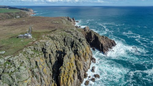
Its intricate and varied granite cliffs include the famous Chair Ladder crag, making it a popular destination for recreational climbers of all abilities. The older and more correct name for the headland is Tol-Pedn-Penwith (locally "Tol-Pedn" for short) which comes from the Cornish for 'the holed headland of Penwith', referring to the awesome vertical blowhole from the clifftop to a sea cave. From 1888 the name was changed to Gwennap Head, perhaps named after a local family, but the new name did not enter local usage until the 1970's.
The inshore waters around the headland are busy with shipping of all sizes. There is a Coastwatch station on the headland in the former coastguard building. The area is also popular with naturalists who, at the appropriate time of the year, can see rare animals such as chough, great shearwater, basking shark and ocean sunfish.
Tol Pedn was once known as Land's End, and in the early 19th century was usually called St. Leven's Land's End in order to distinguish it from the present day Land's End, which was then called Sennen Land's End and Cape Cornwall which has also been known as Land's End.
On the north side of Gwennap Head is a stream that flows into the boulder-strewn cove of Porth Loe. On 14th March 1905 the 'Kyber' was seen from the Wolf Rock, on a bearing to pass The Lizard. The next morning the barque was seen coming ashore at Porth Loe and broke up within fifteen minutes. Men building the nearby coastguard houses used ladders to save three of the crew and a further twenty-three are buried in a mass grave in St Levan churchyard.
There is evidence that the headland has been used as a base for watching ships for centuries. In the Royal Cornwall Museum there is a photograph of a signal station which has been identified as being on Tol-pedn; the Union Flag dating it to before 1801. Early maps also show a station here and a photograph shows a two-arm semaphore dating to circa 1900–10.
The current prominent building was begun in around 1905, as a one-storey Coastguard lookout station, and was opened by 1910. A second storey was added to give extra height to the watch room after a French trawler was wrecked at the foot of Wireless Point, Porthcurno on 14th March 1956. The 'Vert Prairial' could not be seen when she was wrecked, and seventeen crew lost their lives.
There are a pair of cone-shaped navigation markers on Gwennap Head, in line with The Runnelstone Buoy. These are day markers warning vessels of the hazard of the Runnel Stone. The cone to the seaward side is painted red and the inland one is black and white. When at sea the black and white one should always be kept in sight in order to avoid the submerged rocks nearer the shore. If the black and white cone is completely obscured by the red cone then the vessel would be directly on top of The Runnel Stone. The black and white landmark was erected by the Corporation of Trinity House in 1821 – an event recorded on a plaque on the back of the marker. Between 1880 and 1923 over thirty identified steamships were wrecked, stranded or sank in the area. There have been none since 1923.
The Runnel Stone Marine Conservation Zone (also known as Land's End (Runnel Stone)) was designated on 29th January 2016, covers 20 km2 and is based on a 3.5 km arc measured from the NCI lookout. Included is much of the coast from Gwennap Head to Hall Dinas on the east side of Treryn Dinas. As well as protecting deep sea rocks on the Runnel Stone reef, the MCZ also protects other habitats ranging from exposed rock on the coast to soft sediments on the sea floor.
Land's End Porthgwarra The South West Coast Path